Lake Berryessa Rainfall vs Level vs Capacity - A Short Tutorial (1/12/22)
Peter Kilkus
Everyone is excited by the continuing rainfall at Lake Berryessa. The lake is now at 405.6 feet - 35.4 feet below Glory Hole and rising. That's the highest since June 20, 2022. That's an 11.3 foot rise since its low of 394.3 feet on Christmas Eve and 9.5 feet since New Year's Eve (396.1 feet). The lake had reached a low of 394.3 feet on Christmas Day. foot - 45.7 feet below Glory Hole.
Some folks use a rule of thumb that the lake increases a foot in level for every inch of rainfall after the ground has been saturated by 2-3 inches of rain and runoff begins This easy to remember rule is not completely accurate since the relationship between the lake level and its storage capacity is not linear. The lake profile is roughly a V-shaped bowl (with peaks and valleys and inlets and large flat areas), which means that the higher the water level gets the more rain is needed to raise it further. It takes about 25% more rain to go from 430’ to 440’ than it does to go from 390’ to 400’.
Rainfall at Monticello Dam is now at 19.14 inches. Rainfall above the Berryessa Highlands is at 13.07 inches. Cobb Mountain rainfall is at 39.5 inches. In the northern part of the Lake Berryessa watershed, Cobb Mountain and Middletown rainfall is more important to Lake Berryessa levels than rainfall at the dam.
Also, the 1 inch equals 1 foot "rule" is simply an "arbitrary index" relating rainfall at the dam to the rainfall over the whole watershed. The dam is at the south end of the watershed and the rainfall measurement there is the "official" number. But it is not an accurate representation of the rainfall over the whole watershed. It is only a stand-in (index) for the rainfall over the whole watershed.
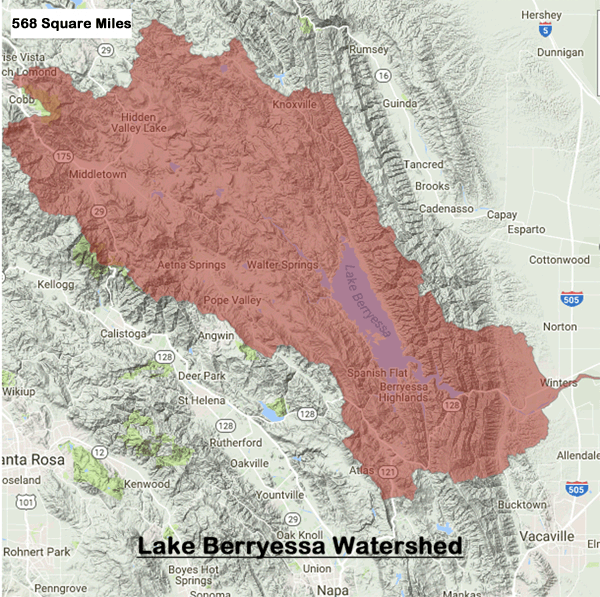
The Lake Berryessa watershed comprises 568 square miles of land with varying rainfall totals due to location and geography. The lake level measurement is an arbitrary relationship to the rainfall at the dam since rainfall at the dam is one of the few actual data points we have. The rainfall on the lake and on the rest of the watershed is averaged into this relationship. For example, when the rainfall at the dam hit 19.4 inches last week, the rainfall total at Cobb Mountain in the northern part of the Lake Berryessa watershed had hit about 44.8 inches.
Previous analysis by the Lake Berryessa News over the last two decades has shown that, at this level, since the lake is a v-shaped bowl, the lake goes up "about" 1 foot per 1 inch of rain. When the lake reaches the 420 foot level the lake then goes up "about" .7 inches per 1 inch of rain.
Some folks have asked me what the Gamble Gauge represents. Since it is a measure of capacity you could assume it's how full the lake is - and you'd be right! I named it after my East Side rancher friend, George Gamble, who likes capacity (how much water is in the lake) rather than lake level as the best understanding of the real water situation.
The Gamble Gauge has risen to 61.6% capacity and continuing to rise with the lake level. The lake now holds 955,100 AF (Acre-Feet) of water. At its low point on 12/3/22 it was at 789,920 AF (50.9%). A full lake holds 1,551,300 AF. (This number used to be 1,602,000 AF but was modified after a detailed bathymetric study in 2013.)
See the real-time details for yourself at: https://www.scwamonitoring.com/LakeBerryessa/
The dam output has dropped from 700 CFS (cubic feet per second) during the summer growing season to about 65 CFS now as the need for irrigation water decreases. By law the minimum output cannot be less than 45 cs (700 cfs =1,388 AF/day; 80 cfs = 159 AF/day; 45 cfs = 89 AF/day). Dam output during the winter has little effect on lake levels.
The Lake Berryessa watershed
encompasses the 576–square mile area primarily fed by Putah Creek which
originates from springs on the eastside of Cobb Mountain in Lake County. Putah
Creek enters Napa County about 11 miles east of Middletown. It merges with Butts
Creek just before it empties into Lake Berryessa. Therefore, rainfall over the
Cobb Mountain and Middletown areas provides the bulk of water entering Lake
Berryessa. One reason that Lake Berryessa rose so quickly in 2017 was the very
heavy rainfall that occurred on Cobb Mountain and Middletown. Rainfall in 2017
at Monticello Dam was 47 inches while at Cobb Mountain it was 130+ inches.
The last few weeks of rain have given us a way to calculate lake level rise versus rainfall. Below is a table of actual rain and level for the recent few weeks.

The analysis below uses the following reasonable assumptions:
After a dry spell it takes more than 2 inches of rain to re-saturate the ground before runoff begins.
There was a dry spell from 12/13/22 to 12/25/22
It takes at least one day for runoff to reach the lake, so the last day's rain (.69) should not be counted as contributing to the lake level rise.
From 12/26/22 to 1/10/23 the lake rose 8.52 feet. (402.9 - 394.38)
If we eliminate the first rainfall of 2.1 inches from 12/26 to 12/30 for re-saturation after the dry spell and eliminate the last day's rainfall for timing to reach the lake, we get a total runoff-enabling rainfall from 12/31/22 to 1/9/23 (eliminating the last rain day) of 8.58 inches.
So 8.52 feet level rise on 8.58 inches of rain gives roughly a 1 foot rise (.993 feet) per inch of rain!
QED
When the lake level gets above 420 feet we can check on the 1 inch of rain raises the lake by 7 inches hypothesis.